Somnath Temple — The Shrine Eternal: Difference between revisions
Bbnanawati (talk | contribs) Add: The kings of Prabhas Patan — builders & rebuilders (1169 prashasti, 1264 Veraval bilingual, Cintra 1287, Chudasama & Ahilyabai restorations, rebuild count) |
Bbnanawati (talk | contribs) Architecture: Bāṇa Stambha explained simply — geography check, gnomon method, honest dating note |
||
| Line 88: | Line 88: | ||
== Architecture == | == Architecture == | ||
The present temple follows the Maru-Gurjara (Solanki) tradition of its predecessor: garbhagriha with pradakshina, gudhamandapa, sabhamandapa and nritya mandapa on an east-facing axis, crowned by a shikhara, kalasha and flag-mast. On the sea-wall stands the '''Bāṇa Stambha''' | The present temple follows the Maru-Gurjara (Solanki) tradition of its predecessor: garbhagriha with pradakshina, gudhamandapa, sabhamandapa and nritya mandapa on an east-facing axis, crowned by a shikhara, kalasha and flag-mast. === The arrow pillar — Bāṇa Stambha, explained simply === | ||
On the temple's sea-wall stands a pillar topped by an arrow — the '''Bāṇa Stambha'''. The arrow points at the open sea, and the Sanskrit line on it makes a startling claim: ''from here, all the way to the South Pole, there is nothing but water.'' | |||
'''Is it true?''' Almost perfectly. If you sailed from the temple straight south and never turned, you would cross about '''9,800 kilometres of open ocean''', and the next coast you touched would be '''Antarctica'''. The Maldives lie east of your path; Africa lies far to the west. Modern maps find only one interruption: about halfway, the line clips the edge of '''Kerguelen''', a frozen island with no people except a research station. One icy island in ten thousand kilometres — the old claim is very nearly exact. And note the direction: ''south'', not north. Northward from Somnath there is no sea at all — only the whole landmass of Asia. | |||
'''How could builders fix directions so exactly, with no compass?''' With a stick and its shadow. Plant a straight rod in the ground, draw a circle around it, and mark the two points where the shadow-tip touches the circle — once in the morning, once in the evening. The line joining those marks runs exactly east–west; cut it in half at a right angle and you have exact north–south. This is the ''śaṅku'' (gnomon) method from India's ancient geometry manuals — and it is why the temple faces precisely east and the arrow points precisely south. Indian astronomers had also long taught that the Earth is a sphere with two poles, so "the southern pole" was a familiar idea at Prabhas centuries before modern maps. | |||
'''What no one could have checked''' is whether the whole southern path was truly empty — no ancient instrument could see across 9,800 km of ocean. That part of the inscription blends the deep-sea experience of Saurashtra's sailors with the old belief in an unbroken southern ocean. The pillar's own age is also uncertain: popular accounts call it ancient, but there is no firm dating, and the pillar seen today stands in the rebuilt complex. Indopedia records it as it is — a tradition whose geography modern maps have proved almost exactly right.<ref name="banstambh">Modern mapping of the 70.4°E meridian from Somnath (20.89°N) to the Antarctic coast; press fact-checks of the Bāṇa Stambha tradition; on the gnomon (śaṅku) method and the spherical earth, the Śulba-sūtras and the ''Sūrya Siddhānta''.</ref> | |||
== Historiography — the many voices == | == Historiography — the many voices == | ||
Revision as of 20:49, 11 June 2026
| File:1869 archive photo of the Somanatha temple, Veraval Gujarat, Exterior 03.jpg The temple ruins, photographed 1869 | |
| Status | First of the twelve Jyotirlingas |
|---|---|
| Location | Prabhas Patan, near Veraval, Saurashtra, Gujarat — shore of the Arabian Sea |
| Deity | Shiva as Somanatha, "Lord of Soma" |
| Sacred site | Prabhas tirtha; sangam of Hiran, Kapila and Saraswati |
| First stone temple | c. 10th century CE |
| Major rebuildings | Bhima I (11th c.); Kumarapala (r. 1143–72); present temple 1947–51 |
| Style | Solanki (Maru-Gurjara) |
| Architect (1951) | Prabhashankar Sompura |
| Jyotirlinga installed | 11 May 1951, by President Rajendra Prasad |
Somnath, at Prabhas Patan on the Saurashtra coast of Gujarat, is revered as the first of the twelve Jyotirlingas of Shiva — the shrines where Shiva is worshipped as a pillar of light. Founded as a stone temple around the 10th century CE on the shore of the Arabian Sea, it became one of the wealthiest and most celebrated temples of its age — and one of the most repeatedly attacked: razed by Mahmud of Ghazni in 1026 CE and damaged or desecrated several times in later centuries, it was rebuilt each time. The present temple, raised 1947–51 at the initiative of Sardar Vallabhbhai Patel and K. M. Munshi, stands as the modern statement of that continuity — "the shrine eternal".[1]
Sacred tradition
Tradition holds that Soma, the moon god, raised the first shrine at Prabhas to honour Shiva, who had freed him from a curse; the deity is therefore Somanatha, Lord of Soma. The Dvadasha Jyotirlinga Stotra opens its enumeration here: Saurāṣṭre Somanāthaṁ… Prabhas is an ancient tirtha, associated with the confluence of the Hiran, Kapila and the unseen Saraswati, and with Krishna's final days at nearby Bhalka. Temple tradition recounts earlier shrines of gold, silver and wood — a succession history cannot verify, but which expresses how the site understands itself: older than any single building upon it.
The temple in history
Rise. A stone temple stood here by the 10th century under the rulers of Saurashtra and the rising Chaulukya (Solanki) dynasty of Gujarat. Indian inscriptions and the Persian and Arabic geographers alike describe a temple of exceptional wealth, endowed with villages, musicians and dancers, drawing pilgrims from across the subcontinent.[2]
The raid of 1026. In January 1026, during the reign of Bhima I, Mahmud of Ghazni crossed the desert, sacked the town, broke the linga and carried away the treasury. Ghaznavid court poets magnified the event as triumph; Indian sources of the period are strikingly quieter — how the raid was remembered, by whom and when, is itself a major scholarly question (see Historiography).[2] The temple was restored, and in the mid-12th century rebuilt in grander form by the Chaulukya king Kumarapala (r. 1143–72), whose Solanki temple is the building the colonial-era photographs record.[3]
Mahmud of Ghazni — the raider and his chroniclers
Mahmud (971–1030), son of the Turkic commander Sebuktigin, ruled Ghazni from 998 and was the first Muslim ruler to take the title Sultan. He built an empire from western Iran to the Punjab, funded by plunder campaigns into India — tradition counts seventeen — and kept a court of poets and scholars that included Ferdowsi and Al-Biruni. Somnath was the climax of his career: marching from Ghazni in October 1025 via Multan and across the desert, he took Prabhas in January 1026 after a fierce defence, broke the linga, and carried away a treasury the chroniclers valued at twenty million dinars. The Caliph in Baghdad showered him with fresh titles for it. He died at Ghazni in 1030.[4]
What his court said about the temple. The most precise contemporary witness is Al-Biruni, who knew India first-hand. He explains the shrine's fame in worldly terms — Somnath "has become so famous because it was the harbour for seafaring people and a station for those who went to and fro between Sufala in the country of the Zanj and China" — a temple at the hinge of Indian Ocean trade. Of the deity: "The linga he raised was the stone of Somnath, for soma means the moon and natha means master, so that the whole word means master of the moon." And of its fate:[5]
"The image was destroyed by the Prince Mahmud… He ordered the upper part to be broken and the remainder to be transported to his residence, Ghaznin, with all its coverings and trappings of gold, jewels, and embroidered garments. Part of it has been thrown into the hippodrome of the town, together with the Cakrasvamin, an idol of bronze, that had been brought from Taneshar" — another fragment was set before the door of the Ghazni mosque, where people wiped their feet on it. (Al-Biruni, trans. Sachau)
The court poet Farrukhi Sistani, who claimed to have ridden on the campaign, supplied the raid's theology: Somnat, he wrote, was really su-Manat — the Arabian goddess Manat, secretly carried to Kathiawar when the Prophet ordered the idols of Arabia destroyed; the historian Gardizi repeats the claim. Baseless as etymology, it shows exactly what the raid was meant to broadcast: Mahmud completing the Prophet's own unfinished commission.[4] A more famous line belongs to legend: Firishta, writing nearly six centuries later, tells of Brahmins offering an immense ransom and Mahmud refusing — were he to accept, "his name would be handed down to posterity as 'Mahmud the idol-seller', whereas he was desirous of being known as 'Mahmud the destroyer'." No early source has the story; historians treat it as later myth-making — yet it became the most quoted line of the episode.[6]
The Indopedia reading. The raider's own publicists are the loudest witnesses to the temple's greatness: every dinar they counted and every title the Caliph conferred measures what Somnath was to India and to the Indian Ocean world. The portal quotes them as evidence of both — the wealth, and the way conquest literature is constructed.[2]
The kings of Prabhas Patan — builders and rebuilders
Temple tradition names four founders in four ages — Soma in gold, Ravana in silver, Krishna in wood, and the stone temple of king Bhimadeva. History's ledger begins with that stone: a temple standing by the 10th century, in the age when Saurashtra passed between the Chudasama kings of Vanthali and the rising Chaulukyas (Solankis) of Anahilavada, whose court traditions — Hemachandra's Dvyashraya and Merutunga's Prabandhachintamani — bind the dynasty's founder Mularaja to Somanatha's worship.[7] When the site was excavated in 1950 before the new temple rose, B. K. Thapar's trench found the earlier temples standing in succession beneath the floor — at Prabhas, the temples are stacked one upon another like the strata of the land itself.[8]
After Mahmud: Bhima I and Kumarapala. The raided temple was rebuilt in stone by Bhima I, the king who had faced the raid.[2] Two generations later Kumarapala raised it anew: the Prabhas Patan prashasti of 1169, composed when the king set the great priest Bhava Brihaspati over the shrine, records that the old temple — by then described as a decayed wooden structure, worn by time — was replaced "in excellent stone, studded with jewels."[9] Read that inscription closely: 143 years after the raid, the kings' own record does not mention Mahmud at all. In the builders' telling the temple simply ages and is renewed, as it always had been; the raider is not granted the dignity of memory. The destruction that fills the Persian chronicles is, in the Sanskrit of Prabhas itself, not even an event.[2]
The Vaghela century — builders and hosts. The Cintra prashasti from the reign of Sarangadeva (1287) records the Shaiva acharya Tripurantaka raising five shrines at Prabhas, the temple precinct still growing.[10] And the most remarkable stone of all: the bilingual Sanskrit–Arabic Veraval inscription of 1264, in the reign of Arjunadeva, records the temple town granting land to the Hormuz shipmaster Nuruddin Firuz to build a mosque — which the Sanskrit text calls a dharmasthana, a house of dharma — with the consent of the Pashupata acharyas, the local raja Chhada, and the merchant guilds of Somanatha-pattana.[11] The lords of the temple were at once its rebuilders and the hosts of an Indian Ocean port open to every faith that traded on it — a fact recorded in their own stone, and almost never in retellings of Somnath.
The Chudasama restorations and the later blows. Ulugh Khan's campaign for Alauddin Khilji struck the temple in 1299; the Chudasama king Mahipala I repaired it in 1308, and his son Khengara installed the linga anew in the decades that followed (c. 1331–1351).[12] Zafar Khan struck in 1395, Mahmud Begada in the 15th century; the building passed into use as a mosque; Aurangzeb ordered its desecration in 1665 and again in 1706.[3] Yet the chain of rebuilders never broke: in 1783 Ahilyabai Holkar of Indore raised the adjacent Somnath temple with its sanctum set underground — so that worship at Prabhas would never again depend on the fate of a roof. Hers is the quiet rebuild between the empires, and worship continued in it until 1951.[12]
How many times? Popular accounts repeat "sixteen" or "seventeen" destructions; the legendary numbers are part of Somnath's story but not of its ledger. The attested chain of rebuildings reads: the 10th-century stone temple · Bhima I's temple (11th century) · Kumarapala's temple (1169 — the building the colonial photographs show in ruin) · the Chudasama restoration (1308–c. 1351) · Ahilyabai's adjacent temple (1783) · the Republic's temple (1951). Six rebuildings stand on the documentary record — and at Prabhas the count of destructions has always mattered less than the certainty of return.[2][13]
The ruin as the camera found it
Henry Cousens of the Archaeological Survey of India described the state of the building in 1931:
"Little now remains of the walls of the temple; they have been, in great measure, rebuilt and patched with rubble to convert the building into a mosque. The great dome, indeed the whole roof and the stumpy minars… are portions of the Muhammadan additions… The great temple, which faces the east, consisted, when entire, of a large central closed hall, or gudhamandapa, with three entrances, each protected with a deep lofty porch, and the shrine — the sanctum sanctorum — which stood upon the west side of the hall, having a broad pradakshina or circumambulatory passage around it."[3]
The 1869 photographs by D. H. Sykes for the ASI, and the albumen prints collected by James Fergusson (Boston Public Library), record precisely this state: the dome and patched walls of the converted ruin.
-
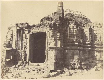 Entrance porch and patched dome — Fergusson Collection, Boston Public Library
 -
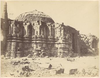 The dome and minar across the fallen masonry — Fergusson Collection
 -
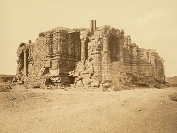 From the west — D. H. Sykes for the ASI, 1869


The "Gates of Somnath" episode (1842)

After the First Anglo-Afghan War, Governor-General Lord Ellenborough ordered the army retreating from Ghazni to carry away the gates of Mahmud's tomb, proclaiming them the sandalwood gates looted from Somnath eight centuries before. Contemporary prints — such as Lockyer Willis Hart's The Sandal Wood Gates of Somnauth (1843)[14] — record the fascination the episode aroused. Examination showed the gates to be deodar, of Ghazni workmanship — not the originals. They were deposited in Agra Fort, and the "Proclamation of the Gates" was ridiculed in Parliament. The episode matters less for the gates than for what it reveals: by 1842, Somnath was already a symbol through which empires announced their intentions to India.
Resurrection (1947–1951)
Days after the accession of Junagadh, Sardar Vallabhbhai Patel pledged at Prabhas on 13 November 1947 that Somnath would rise again. The ruin was taken down after archaeological excavation — B. K. Thapar's dig recorded the earlier temples in succession beneath the shrine — and a new temple in the Solanki style was designed by Prabhashankar Sompura of the hereditary Sompura tradition. K. M. Munshi steered the project after Patel's death; President Rajendra Prasad installed the jyotirlinga on 11 May 1951.[1] The reconstruction also occasioned a foundational debate of the new Republic — Prime Minister Nehru objected to official association with the ceremony — placing Somnath in the history of Indian secularism as well as of Indian devotion.
Architecture
The present temple follows the Maru-Gurjara (Solanki) tradition of its predecessor: garbhagriha with pradakshina, gudhamandapa, sabhamandapa and nritya mandapa on an east-facing axis, crowned by a shikhara, kalasha and flag-mast. === The arrow pillar — Bāṇa Stambha, explained simply === On the temple's sea-wall stands a pillar topped by an arrow — the Bāṇa Stambha. The arrow points at the open sea, and the Sanskrit line on it makes a startling claim: from here, all the way to the South Pole, there is nothing but water.
Is it true? Almost perfectly. If you sailed from the temple straight south and never turned, you would cross about 9,800 kilometres of open ocean, and the next coast you touched would be Antarctica. The Maldives lie east of your path; Africa lies far to the west. Modern maps find only one interruption: about halfway, the line clips the edge of Kerguelen, a frozen island with no people except a research station. One icy island in ten thousand kilometres — the old claim is very nearly exact. And note the direction: south, not north. Northward from Somnath there is no sea at all — only the whole landmass of Asia.
How could builders fix directions so exactly, with no compass? With a stick and its shadow. Plant a straight rod in the ground, draw a circle around it, and mark the two points where the shadow-tip touches the circle — once in the morning, once in the evening. The line joining those marks runs exactly east–west; cut it in half at a right angle and you have exact north–south. This is the śaṅku (gnomon) method from India's ancient geometry manuals — and it is why the temple faces precisely east and the arrow points precisely south. Indian astronomers had also long taught that the Earth is a sphere with two poles, so "the southern pole" was a familiar idea at Prabhas centuries before modern maps.
What no one could have checked is whether the whole southern path was truly empty — no ancient instrument could see across 9,800 km of ocean. That part of the inscription blends the deep-sea experience of Saurashtra's sailors with the old belief in an unbroken southern ocean. The pillar's own age is also uncertain: popular accounts call it ancient, but there is no firm dating, and the pillar seen today stands in the rebuilt complex. Indopedia records it as it is — a tradition whose geography modern maps have proved almost exactly right.[15]
Historiography — the many voices
Somnath is among the most debated sites in Indian historical writing. Turko-Persian chronicles magnified the 1026 raid as a triumph of iconoclasm; colonial historians fixed it as the emblem of "Muslim destruction of Hindu India"; nationalist writing made the rebuilding a metaphor of civilizational resilience[1]; modern scholarship — notably Romila Thapar's Somanatha: The Many Voices of a History[2] and the architectural study of Dhaky and Shastri[13] — examines how each age constructed its own Somnath, noting Sanskrit inscriptions from after 1026 in which the raid is barely remembered, and a 13th-century grant at Somnath itself endowing a mosque. Per Indopedia policy, these readings are presented side by side with their evidence: the destructions are documented fact; their meanings have a history of their own.
Legacy
First among the jyotirlingas in every traditional enumeration; the proving ground of the destruction-and-renewal arc in Indian memory; a touchstone in the Republic's earliest debate on faith and state; and today one of India's most visited pilgrimage sites.
See also
References
- ↑ 1.0 1.1 1.2 Munshi, K. M. Somanatha: The Shrine Eternal. Bharatiya Vidya Bhavan, 1951.
- ↑ 2.0 2.1 2.2 2.3 2.4 2.5 2.6 Thapar, Romila. Somanatha: The Many Voices of a History. 2004.
- ↑ 3.0 3.1 3.2 Cousens, Henry. Somanatha and Other Mediaeval Temples in Kathiawad. Archaeological Survey of India, Imperial Series, 1931.
- ↑ 4.0 4.1 Nazim, M. The Life and Times of Sultan Mahmud of Ghazna. Cambridge, 1931.
- ↑ Al-Biruni. Kitab al-Hind, trans. E. C. Sachau, Alberuni's India, Vol. II (1910).
- ↑ Firishta. Tarikh-i Firishta, trans. J. Briggs, History of the Rise of the Mahomedan Power in India (1829).
- ↑ Hemachandra, Dvyashrayakavya; Merutunga, Prabandhachintamani (1305) — Chaulukya court traditions of Somanatha's patronage.
- ↑ Thapar, B. K., excavation of the Somanatha temple site, 1950 — recorded the successive earlier structures beneath the Kumarapala-period floor.
- ↑ Prabhas Patan (Veraval) prashasti of Bhava Brihaspati, V.S. 1225 = 1169 CE — the foundation inscription of Kumarapala's rebuilding.
- ↑ Cintra prashasti of the reign of Sarangadeva, 1287 CE; ed. G. Bühler, Epigraphia Indica I.
- ↑ Veraval Sanskrit–Arabic bilingual inscription, V.S. 1320 = 1264 CE, reign of Arjunadeva; ed. D. C. Sircar, Epigraphia Indica XXXIV; R. Chakravarti, "Nakhuda Nuruddin Firuz at Somanātha: AD 1264".
- ↑ 12.0 12.1 Gir Somnath district historical records (Government of Gujarat); Cousens 1931.
- ↑ 13.0 13.1 Dhaky, M. A. & Shastri, H. P. The Riddle of the Temple of Somanātha. Varanasi, 1974.
- ↑ Hart, Lockyer Willis. The Sandal Wood Gates of Somnauth, 1843; description of plates by James Atkinson. NYPL Wallach Division.
- ↑ Modern mapping of the 70.4°E meridian from Somnath (20.89°N) to the Antarctic coast; press fact-checks of the Bāṇa Stambha tradition; on the gnomon (śaṅku) method and the spherical earth, the Śulba-sūtras and the Sūrya Siddhānta.
Bibliography (for researchers)
The works cited above, plus: Ghaznavid court sources (Farrukhi Sistani; chronicles of ʿUtbi and Firishta) on the 1026 raid; Al-Biruni's Kitab al-Hind; the Prabhas Patan prashasti of Bhava Brihaspati (1169); the Veraval Sanskrit–Arabic grant of 1264 (Epigraphia Indica XXXIV); the Cintra prashasti of 1287 (Epigraphia Indica I); B. K. Thapar's excavation report (1950); Ellenborough's "Proclamation of the Gates" (1842) and the parliamentary debate upon it.
External references: Archaeological Survey of India · Shree Somnath Trust (somnath.org) · Boston Public Library / Digital Commonwealth · NYPL Digital Collections · British Library, Oriental and India Office Collection